Sunday, February 27, 2011

Year 10 Monday 28/2: Summarising the TRESB Project

HW: 7.8 Dune Revegetation at Stuarts Point (Due Tuesday)
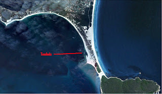
  1. Stuarts Point sand drift area
3. Without effective management of the sand dunes the livelihood of the fishing and tourism industry of the area would be severely compromised by the loss of the dune barrier. Even property would be threatened by the ocean if the dune system was destroyed. These concerns prompted the Stuarts Point Progress Association to approach the Soil Conservation Service of New South Wales for advice and assistance in managing the coastal dunes. In May 1965 they provided native plant seedlings and planting advice to the progress association of Stuarts Point in what was to be the start of the revegetation program for the dunes. Unfortunately this scheme failed when, in August of that year, cattle grazing once again destroyed these sand drift control measures.

4. Without effective management of the sand dunes the livelihood of the fishing and tourism industry of the area would be severely compromised by the loss of the dune barrier. Even property would be threatened by the ocean if the dune system was destroyed.

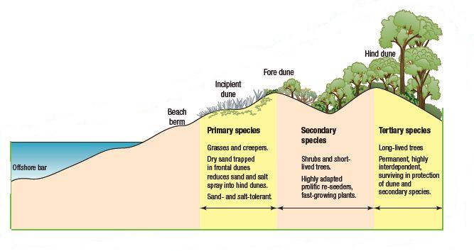
5. On the offshore bar underwater there is little vegetation, at the first point where the beach rises out of the water there is no vegetation, the first vegetation is on the incipient dune in the form of grasses and creepers, the next layer of vegetation is on the fore dune in the form of shrubs and short-lived trees and the last layer on the hind dune is long-lived trees.

6. The roots from the vegetation hold the dune in place and stop it from being washed away easily and the vegetation on the top stop the sand being blown away by strong winds

7. They ate the vegetation so the dunes started to wear away.

8. After the cattle grazing most of the dune would be bare sand, the geographical process altered would be the plants protecting the dunes from being blown away.

9. the Department of Lands, the Department of Public Works, the Macleay Shire Council, and the Soil Conservation Service of New South Wales

10. the first stage involved using a tractor to form a small foredune approximately 1.8 metres high (see 7.36). On top of this a dune-forming fence was constructed to help trap the wind-blown sand and establish the foredune. This dune was essential to protect the hind dunes and allow vegetation to grow. The foredune was then stabilised with coastal spinifex and marram grass. The next stage involved planting trees along the riverbank to stabilise the western margin of the area. After this was completed it was a matter of planting native seedlings in the area between the foredune and the river bank. Initially, fast-growing secondary species like coastal wattle and Casuarina equisetifolia were planted. Once they were established, coastal tertiary species like banksia, melaleuca and leptospermum were planted

12. Longshore Drift

13. a. Sand movement within the dunes is now negligible. A large foredune 3–4 metres high is present and covered with vegetation. This acts to protect the hind dune vegetation from salt-laden winds and erosion from waves. The hind dunes still run east–west as no mechanical work was conducted to repair the wind damage on the hind dunes when the area was revegetated. A coastal dune ecosystem has been re-established on the dunes.

b. The Macleay river ecosystem is now protected as a result of this

c. The community fishing and tourism industry of the area has been restored to its full strenth.

14. Firstly, vegetation on sand dunes protects the dune from being blown away by winds. The vegetation succession that protects the dunes starts with the bare beach, then grasses and creepers on the incipient dune, then shrubs and short-lived trees on the fore dune and finally long-lived trees on the hind dune. Longshore drift as well as strong winds and heavy rain can cause a sand dune to move inland. Close off the dunes and re-plant vegetation and only re-open dunes once vegetation has grown back.

Year 10 Monday 28/2: Summarising the TRESB Project

Write a blog post (including images) which details (a paragraph for each point):

1. The problem which lead to the TRESB Project.
During the 1950s the entrance to the Tweed River, which is at the southern end of the Gold Coast, became a hazard to shipping because of sandbars that were forming across the river mouth.
The easy solution to this problem was to construct breakwaters to stabilise the river entrance and help keep it clear of sand. While these breakwaters initially fixed the problem for shipping, between 1962 and 1965 they had to be extended again due to further sand build-up. At that time the long-term effects on longshore drift and the supply of sand to beaches north of the Tweed River were not considered.
2. The solution to the problem.
The Tweed River Entrance Sand Bypassing Project (TRESBP) provides an example of how people can implement coastal management schemes that re-create the natural processes operating along the coast. The project also involved the cooperation of state and local governments in responding to the community’s concerns and opinions. To date it is one of the most successful coastal management strategies implemented in Australia.  The project aims to replicate the natural process of longshore drift. Sand is pumped from where it accumulates on the southern side of the Tweed River, via a system of pipes, across the Tweed River to one of four outlets where sand is released onto the beach.
3. The result of the project. What areas were effected and how? Do you think that it was a success?
The mouth of the tweed river now has to be constantly maintained so this costs the government a lot of money. But the sand moved is given to the goldcoast which is good for that area. So there are bad points and good points, but I would say it is a success because the river mouth is now safe for ships which is what they aimed to do.

Wednesday, February 23, 2011

Year 10: Coastal Management - The Tweed River Entrance Sand Bypassing Project

In your own blog post answer questions 1-9 on pg 167 of your text book.

  1. The breakwater on the southern side of the Tweed River acted to trap sand that would naturally be moved in a northerly direction by longshore drift. The continual build‑up of sand on the southern side of the breakwater eventually caused the river mouth to once again silt up. It became apparent that continually extending the breakwaters was not the solution to providing a safe entrance to the Tweed River.
  2. In an effort to create a safe river entrance and solve the problem of the beaches immediately north of the
    Tweed being deprived of the natural supply of sand, the accumulating sand at the river mouth was periodically
    dredged and trucked to the Gold Coast where it was used for beach nourishment.
  3. During the 1950s the entrance to the Tweed River, which is at the southern end of the Gold Coast, became a hazard to shipping because of sandbars that were forming across the river mouth. This happened because of longshore drift.
  4. While these breakwaters initially fixed the problem for shipping, between 1962 and 1965 they had to be extended again due to further sand build-up. At that time the long-term effects on longshore drift and the supply of sand to beaches north of the Tweed River were not considered.
  5. Instead of naturally letting the ocean use longshore drift to move the sand, TRESBP pick up the sand in huge quantities and move it themselves, thus stopping the build up of sand and speeding up the process.
  6. TRESBP is very effective as a coastal management solution as it stops the build up of hazardous sand to ships and also recycles the sand by adding it to the goldcoast and therefore helping that environment up there. So by helping 2 environments TRESBP is a very effective and useful coastal management scheme but could eventually lead to the destruction of the longshore drift naturally in place.

  7.  From 1962 onwards the breakwaters have been developed out of the mouth of the river which has stopped the sand coming through with longshore drift, but this has caused the northern beaches to lose sand so it has to be pumped from the south and moved north.
  8. 500m


Monday, February 21, 2011

Year 10 Monday 21/2: The Science of Big Waves

Homework:

Design a blog post on your blog of Maverick waves from different parts of the world. Be sure to describe the geography and the topography of the ocean floor in these areas and how this helps create these massive waves.
 
Location of Jaws, Hawaii
 

"Jaws" is the name given to a big wave surfing reef break on the island of Maui in the U.S. state of Hawaii. It is located on the northern side of the island between mile markers 13 and 14 on the Hana highway and sits at the base of rolling sugar cane field hills.
The surf break, a deep water reef break, is called "Jaws" due to the size and ferocity of the waves. The waves at "Jaws" can reach heights of 120 ft (36.6 m) on the face of the wave, moving as fast as 30 mph (48.3 km/h).
The Jaws surf break is the home of tow-in surfing and has reached its worldwide watersports fame largely due to the frequent filming and photography of tow-in surfing legends performing there on enormous ocean waves breaking at the deep reef off the shore; famed big wave surfers such as tow-in surfing pioneers (also known as "The Strapped Crew"-for the rubber straps on their short surfboards to anchor their feet against the forces) notably Laird Hamilton and Dave Kalama.
 
In order for the surf at "Jaws" to reach its extreme heights, many specific ocean and weather conditions must prevail concurrently. Because ocean swells large enough to produce this kind of surf occur only during winter months, primarily between December and February, they typically coincide with very strong winds which have a large effect on the surf. Other swells, particularly the small but powerful trade wind swells, can make the surf choppy and difficult to ride. There are several other surf spots around the world that boast similar wave heights; however, "Jaws" is famous for its wave forming quality. The reef and rocks at "Jaws" are shaped in a way that magnify incoming swell energy and produce clean and well defined right and left-directional waves with gigantic barreling (hollow, air-filled wave interior) sections.

Sunday, February 20, 2011

Year 10 Monday 21/2: The Science of Big Waves

Pre-viewing:

1. Where do ocean waves come from? What gets them started?
    Waves are generated by wind out on the ocean. 2. What do you think a surfer should know about waves before they try and ride a wave while surfing?
    Even the smallest waves we can surf lift thousands of cubic metres of water as they move along.      That’s like lifting thousands of cars so there is a lot of energy moving around out there in the ocean.

Questions for the Video:


1. Observe all the waves that you see and describe how they form and break. Use as many words found in the segment for you descriptions.
They form out in the North Pacific, come in slowing rolling and leap out of the water like a crocodile, if you get hit, its like being catapulted.2. Describe how waves are formed, how they originate, and how they are measured?
Waves are formed in the 'wave factory' the North Pacific ocean, they are formed when big low pressure centres create a big difference between high and low, they are measured by wave height, the period (time from crest to crest) and the wave length (distance between the two peaks)3. What is a maverick wave and what is special about the way it is formed?
Maverick waves are huge waves formed at the spot known as "Mavericks", they are formed out in the deep ocean but as they come in the huge mass of them is compressed against the shallow depth and therefore the only way the water can go is up and therefore making a huge wave.4. How is energy stored and transferred during wave?
It is stored underneath, in the deep water, and then explodes up as the water gets shallower.5. List any kind of advice given by the surfers about how to survive these “big waves.”
 - respect the waves
 - Get in there, catch one, before the wrath of the gods comes down on you

Homework:

Design a blog post on your blog of Maverick waves from different parts of the world. Be sure to describe the geography and the topography of the ocean floor in these areas and how this helps create these massive waves.

"Jaws" is the name given to a big wave surfing reef break on the island of Maui in the U.S. state of Hawaii. It is located on the northern side of the island between mile markers 13 and 14 on the Hana highway and sits at the base of rolling sugar cane field hills.
The surf break, a deep water reef break, is called "Jaws" due to the size and ferocity of the waves. The waves at "Jaws" can reach heights of 120 ft (36.6 m) on the face of the wave, moving as fast as 30 mph (48.3 km/h).
The Jaws surf break is the home of tow-in surfing and has reached its worldwide watersports fame largely due to the frequent filming and photography of tow-in surfing legends performing there on enormous ocean waves breaking at the deep reef off the shore; famed big wave surfers such as tow-in surfing pioneers (also known as "The Strapped Crew"-for the rubber straps on their short surfboards to anchor their feet against the forces) notably Laird Hamilton and Dave Kalama.
In order for the surf at "Jaws" to reach its extreme heights, many specific ocean and weather conditions must prevail concurrently. Because ocean swells large enough to produce this kind of surf occur only during winter months, primarily between December and February, they typically coincide with very strong winds which have a large effect on the surf. Other swells, particularly the small but powerful trade wind swells, can make the surf choppy and difficult to ride. There are several other surf spots around the world that boast similar wave heights; however, "Jaws" is famous for its wave forming quality. The reef and rocks at "Jaws" are shaped in a way that magnify incoming swell energy and produce clean and well defined right and left-directional waves with gigantic barreling (hollow, air-filled wave interior) sections.


Sunday, February 13, 2011

Mapping Skills 7.5 Coastal Management on the Gold Coast

7.5 Coastal Management on the Gold Coast


Refer to the topographic map and aerial photograph on pages 164 and 165 to answer the following questions.

* Required


9 Calculate the following:


13 Name the human features located at the following grid references:


14 Name the natural features located at the following grid references:


18 Estimate the bearing of the following features from the water tank on the top of Mount Murraba:


Year 10: 7.3 Geographical Processes Shaping the Coastal Environment

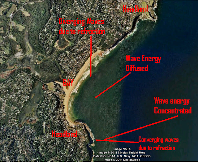
1. For the first image use Google maps to find a beach that is of similar shape. Capture it and label the picture with the information in the diagram 7.7

2. Find pictures for each of these coastal features in the next TWO pictures (do at least 10) (7.13 + 7.9). Copy them to your blog post and label them. (you don't have to do 'beach'). Post to blog


3. Find a picture of a Headland with a Wave-Cut Platform and label it with the information in 7.8. Post to blog.


Monday, February 7, 2011

Year 10: 7.2 Waves - Water on the Move


7.1 Question 7

7 Study the inappropriate development image. Select one
of the viewpoints below and write a letter to the local
paper about the advantages and/or disadvantages of the
development.
a a resident of one of the new developments shown in
the picture
b a long-time local resident of the area who appreciates
7. a) Dear, Local Paper
I'm writing to say how pleased I am with the new apartments that you built along the beach line. The view is amazing and the apartments are very well designed. I've finally found a place to settle down in and enjoy my life.
The only problem I have is that I'm interested in buying a dog but they are not allowed in the complex. Hopefully I can persuade someone to change this. All my neighbours are very nice to me tho and I'm making some great friends. There a still a few apartments for sale and I advise anyone looking for a nice, relaxed, and beautiful environment to live in to come live here!
Sincerely,
Anonymous

Sunday, February 6, 2011

Coastal Management Questions 7.1

85 percent of the population live within 50km of the coastal zone and this leads to overcrowding and damage of the coastal environment
So we can protect the coastline and apply new technology
The trend of people moving from big cities to the coastline

Pollution - Not properly recycling/disposing of rubbish
Population growth - Moving from cities to the coastline
Tourism and Recreational pressures - Building resorts and tourist attractions
Coastal rivers and lagoons - Silting up due to human and natural activity


They come up with sustainable ideas to protect the coast and make it more enjoyable for beachgoers.