HW: 7.8 Dune Revegetation at Stuarts Point (Due Tuesday)
- Stuarts Point sand drift area

4. Without effective management of the sand dunes the livelihood of the fishing and tourism industry of the area would be severely compromised by the loss of the dune barrier. Even property would be threatened by the ocean if the dune system was destroyed.
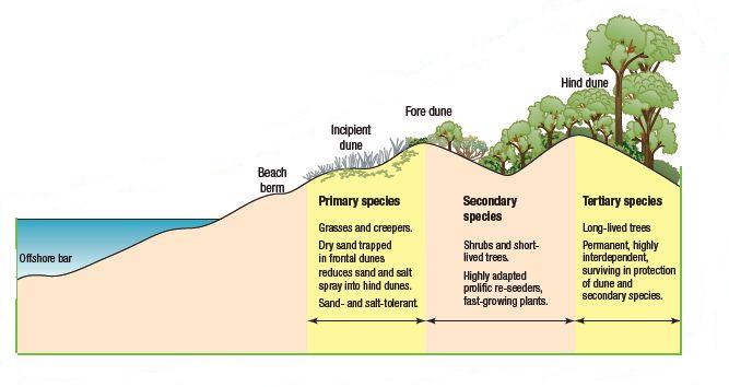
5. On the offshore bar underwater there is little vegetation, at the first point where the beach rises out of the water there is no vegetation, the first vegetation is on the incipient dune in the form of grasses and creepers, the next layer of vegetation is on the fore dune in the form of shrubs and short-lived trees and the last layer on the hind dune is long-lived trees.
6. The roots from the vegetation hold the dune in place and stop it from being washed away easily and the vegetation on the top stop the sand being blown away by strong winds
7. They ate the vegetation so the dunes started to wear away.
8. After the cattle grazing most of the dune would be bare sand, the geographical process altered would be the plants protecting the dunes from being blown away.
9. the Department of Lands, the Department of Public Works, the Macleay Shire Council, and the Soil Conservation Service of New South Wales
10. the first stage involved using a tractor to form a small foredune approximately 1.8 metres high (see 7.36). On top of this a dune-forming fence was constructed to help trap the wind-blown sand and establish the foredune. This dune was essential to protect the hind dunes and allow vegetation to grow. The foredune was then stabilised with coastal spinifex and marram grass. The next stage involved planting trees along the riverbank to stabilise the western margin of the area. After this was completed it was a matter of planting native seedlings in the area between the foredune and the river bank. Initially, fast-growing secondary species like coastal wattle and Casuarina equisetifolia were planted. Once they were established, coastal tertiary species like banksia, melaleuca and leptospermum were planted
12. Longshore Drift
13. a. Sand movement within the dunes is now negligible. A large foredune 3–4 metres high is present and covered with vegetation. This acts to protect the hind dune vegetation from salt-laden winds and erosion from waves. The hind dunes still run east–west as no mechanical work was conducted to repair the wind damage on the hind dunes when the area was revegetated. A coastal dune ecosystem has been re-established on the dunes.
b. The Macleay river ecosystem is now protected as a result of this
c. The community fishing and tourism industry of the area has been restored to its full strenth.
14. Firstly, vegetation on sand dunes protects the dune from being blown away by winds. The vegetation succession that protects the dunes starts with the bare beach, then grasses and creepers on the incipient dune, then shrubs and short-lived trees on the fore dune and finally long-lived trees on the hind dune. Longshore drift as well as strong winds and heavy rain can cause a sand dune to move inland. Close off the dunes and re-plant vegetation and only re-open dunes once vegetation has grown back.
No comments:
Post a Comment